← All routes
Trek Magallanes — Torres del Paine National Park, Chile

The W Trek, Torres del Paine

Four days tracing a giant 'W' through Patagonia's most famous park — the granite towers at dawn, the hanging glaciers of the French Valley, and the blue wall of Grey Glacier.

The W Trek, Torres del Paine
Photo: Karen Chan 16 · CC BY 2.0
Duration
4 days
Distance
75 km
Ascent
2500 m
Difficulty
Hard
Best season
Patagonian summer, roughly November–March (long days, but book refuges months ahead)

The W Trek is the classic introduction to Torres del Paine, threading the three great valleys of the Cordillera del Paine in the shape of a letter W. In four demanding but non-technical days it links the park’s three signature sights: the sheer granite Towers that give the park its name, the amphitheatre of the French Valley, and the icefield-fed Grey Glacier.

This itinerary runs east to west, saving the great glacier for last, though many walk it the other way.

Getting there. Fly or bus to Puerto Natales, the gateway town, then take the park bus (about 2 hours) to the Laguna Amarga entrance. A short shuttle and, later, catamarans across Lago Pehoé link the sectors.

Permits & beds. Park entry must be booked online in advance, and every night you must have a reserved bed or campsite at a refuge run by the two concessionaires. In summer these sell out months ahead — arrange the whole chain of nights before you fly.

Good to know:

Day 1

Base of the Towers

Refugio Central (Las Torres sector) → Refugio Central 20 km ↑ 900 m

From the eastern sector, climb the Ascencio valley to the glacial tarn beneath the Torres del Paine themselves, then return the same way to camp.

Segments

  1. Up the Ascencio valley 6 km ↑ 450 m

    Refugio Central → Refugio Chileno

    Windy ridge and river valley

    Climb the exposed 'Windy Pass' above the Ascencio river, then contour into the sheltered valley to Refugio Chileno. About 2.5 hours.

  2. The final boulder field to the Mirador
    The final boulder field to the Mirador 4 km ↑ 450 m

    Refugio Chileno → Mirador Las Torres (~900 m)

    Forest then steep moraine boulders

    Walk up through southern beech forest, then scramble the last steep hour over a chaos of moraine boulders to the tarn beneath the three towers — the iconic view of the park. About 2 hours up.

    About this place

    The Cordillera Paine is a group of mountains in Torres del Paine National Park in Chilean Patagonia. It is 280 km (170 mi) north of Punta Arenas, and about 1,960 km (1,220 mi) south of the Chilean capital Santiago. The cordillera is part of the Commune of Torres del Paine in Última Esperanza Province of Magallanes and Antártica Chilena Region. No accurate surveys have been published, and published elevations have been claimed to be seriously inflated, so most of the elevations given on this page are approximate. Paine means "blue" in the native Tehuelche (Aonikenk) language and is pronounced PIE-nay.

    Read more on Wikipedia ↗

    Photo: Karen Chan 16 · CC BY 2.0

Day 2

Along Lago Nordenskjöld

Refugio Central → Refugio Francés 17 km ↑ 400 m

Leave the Towers behind and follow the north shore of Lago Nordenskjöld westward beneath the horned peaks of the Cuernos del Paine to the Francés sector.

Segments

  1. Shoreline to Los Cuernos
    Shoreline to Los Cuernos 11 km ↑ 250 m

    Refugio Central → Refugio Los Cuernos

    Rolling lakeshore trail

    An undulating path along the turquoise Lago Nordenskjöld, often into fierce wind, with the sheer Cuernos rising directly overhead. About 4 hours.

    About this place

    The Cordillera Paine is a group of mountains in Torres del Paine National Park in Chilean Patagonia. It is 280 km (170 mi) north of Punta Arenas, and about 1,960 km (1,220 mi) south of the Chilean capital Santiago. The cordillera is part of the Commune of Torres del Paine in Última Esperanza Province of Magallanes and Antártica Chilena Region. No accurate surveys have been published, and published elevations have been claimed to be seriously inflated, so most of the elevations given on this page are approximate. Paine means "blue" in the native Tehuelche (Aonikenk) language and is pronounced PIE-nay.

    Read more on Wikipedia ↗

    Photo: Karen Chan 16 · CC BY 2.0

  2. On to the French sector 6 km ↑ 150 m

    Refugio Los Cuernos → Refugio Francés

    Rocky lakeside path

    Continue west along the shore to the Francés sector at the mouth of the French Valley, the base for the next day's climb. About 2 hours.

Day 3

The French Valley

Refugio Francés → Refugio Paine Grande 20 km ↑ 700 m

Climb into the heart of the massif to the French Valley lookouts, watching avalanches peel off the Paine Grande glacier, then descend and cross to Refugio Paine Grande.

Segments

  1. Into the Valle Francés
    Into the Valle Francés 9 km ↑ 600 m

    Refugio Francés → Mirador Francés / Británico

    Steep forest and moraine

    Climb the valley past the Mirador Francés, where hanging glaciers calve off the flank of Cerro Paine Grande, up to the higher Británico lookout ringed by granite walls. Then return to Italiano. About 5 hours round trip.

    About this place

    The Cordillera Paine is a group of mountains in Torres del Paine National Park in Chilean Patagonia. It is 280 km (170 mi) north of Punta Arenas, and about 1,960 km (1,220 mi) south of the Chilean capital Santiago. The cordillera is part of the Commune of Torres del Paine in Última Esperanza Province of Magallanes and Antártica Chilena Region. No accurate surveys have been published, and published elevations have been claimed to be seriously inflated, so most of the elevations given on this page are approximate. Paine means "blue" in the native Tehuelche (Aonikenk) language and is pronounced PIE-nay.

    Read more on Wikipedia ↗

    Photo: Karen Chan 16 · CC BY 2.0

  2. West to Lago Pehoé 8 km ↑ 100 m

    Italiano → Refugio Paine Grande

    Open grassland and low ridges

    Descend from the valley mouth and cross open, wind-blasted country to the large refuge at Paine Grande on the shore of Lago Pehoé. About 2.5 hours.

Day 4

Grey Glacier

Refugio Paine Grande → Refugio Paine Grande 18 km ↑ 500 m

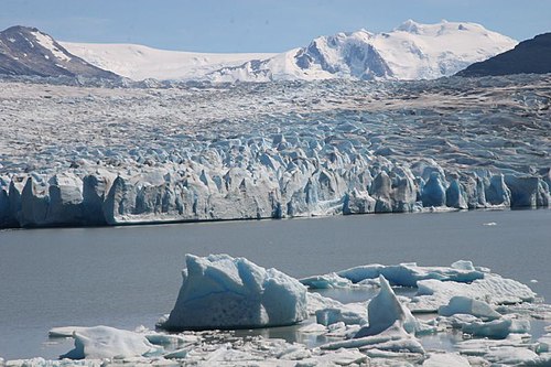
Follow the western arm north to stand above the icebergs and blue seracs of Grey Glacier, the trek’s grand finale, then return to Paine Grande for the boat out.

Segments

  1. Up to the glacier viewpoints
    Up to the glacier viewpoints 11 km ↑ 400 m

    Refugio Paine Grande → Refugio Grey / Grey Glacier lookouts

    Ridges above the lake, some ladders

    Climb over a series of ridges above Lago Grey, past viewpoints crowded with stranded icebergs, to look out over the immense wall of Grey Glacier flowing off the Southern Patagonian Icefield. About 3.5 hours.

    About this place

    Grey Glacier is a glacier in the Southern Patagonian Ice Field, just west of the Cordillera del Paine. It flows southward into the lake of the same name. Before dividing in two at its front end, the glacier is 6 kilometers wide and over 30 meters high. In 1996, it occupied a total area of 270 km2 (100 sq mi) and a length of 28 km (17 mi). In November 2017 a large iceberg broke off the glacier.

    Read more on Wikipedia ↗

    Photo: welsh boy from London, U.K. · CC BY-SA 2.0

  2. Return to the catamaran 7 km ↑ 100 m

    Grey Glacier lookouts → Refugio Paine Grande

    Ridge trail

    Retrace the ridge trail back to Paine Grande to catch the catamaran across Lago Pehoé and the bus out of the park. About 3 hours.