← All routes
Trek Khumbu — Sagarmatha National Park, Nepal

Everest Base Camp Trek: The 8-Day Highlights

An accelerated highlights version of the classic trek through the Khumbu — from the airstrip at Lukla up the Sherpa valleys to the foot of the world's highest mountain at 5,364 m.

Everest Base Camp Trek: The 8-Day Highlights
Photo: Rdevany · CC BY-SA 3.0
Duration
8 days
Distance
110 km
Ascent
3200 m
Difficulty
Hard
Best season
Pre-monsoon spring (March–May) and post-monsoon autumn (late September–November)

This is the walk to the base of Everest itself, following the Sherpa trading trails of the Khumbu from the mountain airstrip at Lukla to the glacier at 5,364 m. This 8-day highlights itinerary strings together the essential stages — Lukla, Namche Bazaar, Tengboche, Dingboche, Lobuche and Gorak Shep — for trekkers who are already fit and short on time.

Altitude, not distance, is the real difficulty. The classic route builds in extra acclimatisation days at Namche and Dingboche; on this compressed version you should be confident with altitude, walk slowly, and turn back if symptoms appear.

Getting there. Fly to Kathmandu, then take the short, dramatic mountain flight to Lukla (2,860 m), where the trek begins. Most trekkers walk back down the same valleys, or fly out from Lukla; some take a helicopter from Gorak Shep or Pheriche to save the return days.

Permits & tickets. You need the Sagarmatha National Park entry permit and the local Khumbu Pasang Lhamu Rural Municipality permit, both bought en route or in Kathmandu. A licensed guide is now required for trekking in the region.

Good to know:

Day 1

Lukla to Phakding

Lukla (2,860 m) → Phakding (2,610 m) 8 km ↑ 200 m

An easy first afternoon losing height along the river, to sleep low before the big climb to Namche.

Segments

  1. Off the airstrip
    Off the airstrip 3 km ↑ 40 m

    Lukla airport → Cheplung

    Stone village path

    Leave Lukla's clifftop airstrip and follow the well-trodden trail through Sherpa villages and prayer walls, contouring gently above the Dudh Koshi river. About 1 hour.

    About this place

    Lukla is a small town in the Khumbu Pasang Lhamu rural municipality of the Solukhumbu District in the Koshi Province of northeastern Nepal. Situated at 2,860 metres (9,383 ft) above sea level, it is a popular place for visitors to the Himalayas near Mount Everest to arrive. Although Lukla means "place with many goats and sheep", few of them are found in the area now.

    Read more on Wikipedia ↗

    Photo: Vyacheslav Argenberg · CC BY 4.0

  2. Down to the river
    Down to the river 5 km ↑ 160 m

    Cheplung → Phakding (2,610 m)

    River valley path

    Descend steadily to the riverside village of Phakding, crossing the first of many suspension bridges strung with prayer flags. The night is spent low on purpose, to aid acclimatisation. About 2 hours.

    About this place

    Phakding is a small village in the Khumbu region of Nepal. It lies in the Dudh Kosi river valley just north of Lukla and south of Monjo, at an altitude of 2,610 m. It has been a UNESCO World Heritage Site since 1979. Phakding has a population of 550 locals, mostly Sherpa and Tamang. All of these people belong to Tibetan Buddhism and pray in a small Gompa at the centre of the village. Phakding lies on ward no 3 of Khumbu Pasanglhamu Rural Municipality.

    Read more on Wikipedia ↗

    Photo: DARIO SEVERI · CC BY-SA 3.0

Day 2

Phakding to Namche Bazaar

Phakding (2,610 m) → Namche Bazaar (3,440 m) 11 km ↑ 830 m

A long river walk into the national park, then a steep forested climb with the first glimpse of Everest to the trading town of Namche.

Segments

  1. Into Sagarmatha National Park
    Into Sagarmatha National Park 5 km ↑ 220 m

    Phakding → Monjo park gate

    River path and suspension bridges

    Follow the Dudh Koshi upstream, crossing and re-crossing on high bridges, to the park entrance at Monjo where permits are checked. About 2.5 hours.

    About this place

    Sagarmāthā National Park is a national park in the Himalayas of eastern Nepal that was established in 1976 and encompasses an area of 1,148 km2 (443 sq mi) in the Solukhumbu District. It ranges in elevation from 2,845 to 8,848 m and includes Mount Everest. In the north, it borders Qomolangma National Nature Preserve, and Makalu Barun National Park in the east; in the south, it extends to Dudh Kosi river. It is part of the Sacred Himalayan Landscape.

    Read more on Wikipedia ↗

    Photo: Vyacheslav Argenberg · CC BY 4.0

  2. The Namche hill
    The Namche hill 6 km ↑ 610 m

    Monjo → Namche Bazaar (3,440 m)

    Steep forest switchbacks

    Cross the high Hillary Suspension Bridge, then climb a long forested staircase — with a first distant view of Everest on a clear day — to Namche Bazaar, the horseshoe-shaped Sherpa capital and trading hub. About 3.5 hours.

    About this place

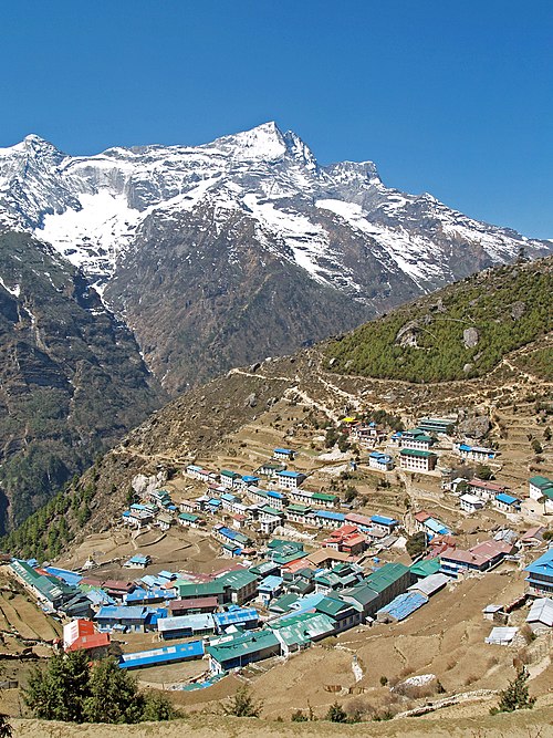
    Namche Bazaar is a town in the Ward number 5 of Khumbu Pasanglhamu Rural Municipality in Solukhumbu District of Koshi Province in northeastern Nepal. It is located within the Khumbu area at 3,440 metres (11,286 ft) at its low point, populating the sides of a hill. Most Sherpa in the tourism business hail from the Namche area. Namche is also the main trading center and hub for the Lanjey region.

    Read more on Wikipedia ↗

    Photo: stevehicks · CC BY 2.0

Day 3

Namche Bazaar to Tengboche

Namche Bazaar (3,440 m) → Tengboche (3,867 m) 10 km ↑ 700 m

A high contouring trail with sweeping mountain views, a drop to the river, then a steady climb to the monastery at Tengboche.

Segments

  1. The panorama trail
    The panorama trail 5 km ↑ 100 m

    Namche Bazaar → Phunki Thanga

    High contour path, then descent

    Contour along an open hillside with grand views of Everest, Lhotse and the fluted peak of Ama Dablam, then descend to the river at Phunki Thanga. About 2.5 hours.

    About this place

    Ama Dablam is a mountain in the Eastern Himalayas range of Koshi Province, Nepal. The main peak is 6,812 metres (22,349 ft), the lower western peak is 6,170 metres (20,243 ft). The name Ama Dablam literally means 'mother's charm box' in the Sherpa language; the long ridges on each side like the arms of a mother (ama) protecting her child, and the hanging glacier thought of as the dablam, the traditional double-pendant containing pictures of the gods, worn by Sherpa women. For several days, Ama Dablam dominates the eastern sky for anyone trekking to Mount Everest Base Camp. Because of its soaring ridges and steep faces, Ama Dablam is sometimes referred as the "Matterhorn of the Himalayas". The mountain is featured on the one rupee Nepalese banknote.

    Read more on Wikipedia ↗

    Photo: Vyacheslav Argenberg · CC BY 4.0

  2. Climb to the monastery
    Climb to the monastery 5 km ↑ 600 m

    Phunki Thanga → Tengboche (3,867 m)

    Steep forest climb

    Climb steadily through rhododendron forest to Tengboche, home to the largest Buddhist monastery in the Khumbu, set on a saddle facing Ama Dablam. About 2.5 hours.

    About this place

    Tengboche is a village in Khumbu Pasanglhamu rural municipality in the Khumbu subregion of Koshi Province in Nepal, located at 3,867 metres (12,687 ft). Within the village is an important Buddhist monastery, Tengboche Monastery, which is the largest gompa in the Khumbu region. The structure was built in 1923. In 1934, it was destroyed by an earthquake but subsequently rebuilt. It was destroyed again by a fire in 1989, and again rebuilt with the help of volunteers and the provision of foreign aid. Tengboche has a panoramic view of the Himalayan mountains, including the well-known peaks of Tawache, Everest, Nuptse, Lhotse, Ama Dablam, and Thamserku. Tenzing Norgay, the first man to reach the summit of Mount Everest with Sir Edmund Hillary, was born in the area in the village of Thani and was once sent to Tengboche Monastery to be a monk.

    Read more on Wikipedia ↗

    Photo: Vyacheslav Argenberg · CC BY 4.0

Day 4

Tengboche to Dingboche

Tengboche (3,867 m) → Dingboche (4,410 m) 11 km ↑ 550 m

Descend to the river, then a long climb past Pangboche onto the open, wind-scoured slopes of the Imja valley.

Segments

  1. Through Pangboche
    Through Pangboche 5 km ↑ 250 m

    Tengboche → Pangboche (3,930 m)

    River crossing and climb

    Drop to the Imja Khola, then climb to Pangboche, the highest year-round village on the route and home to an old monastery. About 2.5 hours.

    About this place

    Pangboche or Panboche is a village in Khumjung Village Development Committee of Solukhumbu District in Province No. 1 of Nepal at an altitude of 13,074 feet (3,985 m). It is located high in the Himalayas in the Imja Khole valley, about 3 kilometres northeast of Tengboche and is a base camp for climbing the nearby Ama Dablam and trekking. It contains a monastery, famed for its purported yeti scalp and hand, the latter of which was stolen. The village is inhabited mainly by Sherpas, and Sungdare Sherpa, a native of the village, held the record for summiting Everest five times in the Sherpa climbing history and in the world history of mountaineering in 1989. The Pangboche school was built by Sir Edmund Hillary's Himalayan Trust in 1963. North of the village is the Dughla lake and pass.

    Read more on Wikipedia ↗

    Photo: Moralist · CC BY-SA 3.0

  2. Into the Imja valley
    Into the Imja valley 6 km ↑ 480 m

    Pangboche → Dingboche (4,410 m)

    Open alpine valley above the treeline

    Leave the last trees behind and climb the broad Imja valley to the stone-walled fields of Dingboche, a good place to feel the thinning air. About 2.5 hours.

    About this place

    Dingboche is a Sherpa village at an elevation of 4,410 m (14,470 ft) in the Khumbu region of northeastern Nepal. Its population was estimated at 200 in 2011.

    Read more on Wikipedia ↗

    Photo: Nirojsedhai · CC BY-SA 4.0

Day 5

Dingboche to Lobuche

Dingboche (4,410 m) → Lobuche (4,940 m) 9 km ↑ 530 m

A gradual climb to Thukla, a steep pull to the memorial ridge for lost Everest climbers, then a walk beside the Khumbu Glacier to Lobuche.

Segments

  1. The Thukla climb
    The Thukla climb 5 km ↑ 420 m

    Dingboche → Thukla Pass memorials (4,830 m)

    Alpine trail and steep moraine

    Cross open pasture to Thukla, then climb a steep moraine slope to the moving row of stone memorials to climbers who died on Everest. About 3 hours.

    About this place

    The Khumbu Glacier is located in the Khumbu region of northeastern Nepal between Mount Everest and the Lhotse-Nuptse ridge. With elevations of 4,900 m (16,100 ft) at its terminus to 7,600 m (24,900 ft) at its source, it is the world's highest glacier. The Khumbu Glacier is followed for the final part of the trail to one of the Everest Base Camps. The start of the glacier is in the Western Cwm near Everest. The glacier has a large icefall, the Khumbu Icefall, at the west end of the lower Western Cwm. This icefall is the first major obstacle—and among the more dangerous—on the standard south col route to the Everest summit. It is also the largest glacier in Nepal.

    Read more on Wikipedia ↗

    Photo: Wikimedia Commons · CC BY-SA 3.0

  2. Beside the glacier
    Beside the glacier 4 km ↑ 110 m

    Thukla Pass → Lobuche (4,940 m)

    Glacial moraine path

    Follow the lateral moraine of the Khumbu Glacier on a gentler grade to the cluster of lodges at Lobuche, the last stop before Base Camp. About 1.5 hours.

    About this place

    Lobuche is a Nepalese mountain which lies close to the Khumbu Glacier and the settlement of Lobuche. There are two main peaks, Lobuche East and Lobuche West. A permit to climb the mountain is required from the Nepal Mountaineering Association (NMA), which classifies Lobuche East (6,119m) as a "trekking peak" and Lobuche West (6,145m) as an "expedition peak". The permit is issued by Nepal Mountaineering Association and costs USD $350 during spring, USD $175 during autumn, and USD $175 during winter/summer. The easier, trekking peak, the East peak is climbed far more frequently than the West peak; however, most of those climbers only do so to reach a false summit that is still a few hours from the true summit of Lobuche East. Between the two peaks is a long, deeply notched ridge, with a steep drop and its considerable distance making an approach of the West peak from the East practically impossible.

    Read more on Wikipedia ↗

    Photo: Theprotrekker · CC BY-SA 4.0

Day 6

Lobuche to Everest Base Camp

Lobuche (4,940 m) → Gorak Shep (5,164 m) 15 km ↑ 600 m

A demanding day on rough glacial terrain to Gorak Shep and out along the moraine to Base Camp at 5,364 m, returning to sleep at Gorak Shep.

Segments

  1. Lobuche to Gorak Shep
    Lobuche to Gorak Shep 5 km ↑ 240 m

    Lobuche → Gorak Shep (5,164 m)

    Rough glacial moraine

    Pick a way across boulder-strewn moraine beside the Khumbu Glacier to the bleak sandy flat of Gorak Shep, the last settlement on the trek. About 3 hours.

    About this place

    Gorak Shep, also spelled Gorakshep, is a settlement nestled on the periphery of a frozen lakebed blanketed with sand in Nepal, sharing its name with the locale. Situated at an elevation of 5,164 meters near Mount Everest, it remains uninhabited for most of the year, reopening only for the Mount Everest trekking season.

    Read more on Wikipedia ↗

    Photo: Vyacheslav Argenberg · CC BY 4.0

  2. Out to Base Camp
    Out to Base Camp 5 km ↑ 200 m

    Gorak Shep → Everest Base Camp (5,364 m)

    Undulating moraine trail

    Follow the moraine to Everest Base Camp at the foot of the tumbling Khumbu Icefall — the staging point for summit expeditions and the goal of the whole trek. About 2.5 hours out.

    About this place

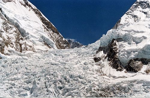
    The Khumbu Icefall is located at the head of the Khumbu Glacier and the foot of the Western Cwm. It lies at an elevation of 5,486 metres (17,999 ft) on the Nepalese slopes of Mount Everest, not far above Base Camp and southwest of the summit. The icefall is regarded as one of the most dangerous sections of the South Col route to Everest's summit.

    Read more on Wikipedia ↗

    Photo: Wikimedia Commons · CC BY-SA 3.0

  3. Return to Gorak Shep
    Return to Gorak Shep 5 km ↑ 0 m

    Everest Base Camp → Gorak Shep (5,164 m)

    Moraine trail

    Retrace the moraine to Gorak Shep for the night, sleeping at 5,164 m — the highest camp of the trek. About 2 hours.

    About this place

    There are two base camps on Mount Everest, on opposite sides of the mountain: South Base Camp is in Nepal at an altitude of 5,364 metres (17,598 ft), while North Base Camp is in Tibet at 5,150 metres (16,900 ft).

    Read more on Wikipedia ↗

    Photo: Peellden · CC BY-SA 3.0

Day 7

Kala Patthar and the descent to Pheriche

Gorak Shep (5,164 m) → Pheriche (4,240 m) 15 km ↑ 400 m

Climb Kala Patthar in the dark for sunrise on Everest, then begin the return, descending steeply back down the valley to the thicker air of Pheriche.

Segments

  1. Kala Patthar at dawn
    Kala Patthar at dawn 2 km ↑ 380 m

    Gorak Shep → Kala Patthar (5,545 m)

    Steep rocky ridge

    Set off in the dark for the steep climb to Kala Patthar, the highest point of the trek, for the finest unobstructed view of Everest's summit at sunrise. About 2 hours up.

    About this place

    Kala Patthar is a notable landmark located on the south ridge of Pumori in the Nepali Himalayas above Gorakshep. Although not a proper mountain, with a prominence of only 10 m (33 ft), the ascent of Kala Patthar is very popular with trekkers in the region of Mount Everest since it provides the most accessible closeup view of Everest. Due to the structure of the Everest Massif, its high summit is blocked by Nuptse from much of the surrounding region.

    Read more on Wikipedia ↗

    Photo: Vyacheslav Argenberg · CC BY 4.0

  2. Down to Pheriche
    Down to Pheriche 13 km ↑ 20 m

    Gorak Shep → Pheriche (4,240 m)

    Glacial moraine and valley trail

    Begin the return: retrace the moraine past Lobuche and down the Thukla slope, then follow the valley to the exposed village of Pheriche, dropping over 900 m to sleep in noticeably richer air. About 5 hours.

    About this place

    Pheriche is a village in the Khumbu region of eastern Nepal. Situated at an altitude of about 4,371 m (14,340 ft), above the Tsola River, Pheriche is a popular stop for trekkers and climbers. There is a rudimentary hospital in Pheriche managed by the Himalayan Rescue Association. The Pheriche hospital is open only during the two trekking/climbing seasons. Although the hospital was built with Japanese support in 1975, it is staffed by Nepalis and volunteer physicians who are mostly from the US, Europe, Canada and Australia.

    Read more on Wikipedia ↗

    Photo: Babin Dulal · CC BY-SA 4.0

Day 8

Pheriche to Namche Bazaar

Pheriche (4,240 m) → Namche Bazaar (3,440 m) 17 km ↑ 500 m

A long downhill day retracing the trail through Tengboche and the forests above the Dudh Koshi to Namche Bazaar, from where trekkers walk out to Lukla the next morning for the flight home.

Segments

  1. Back over the monastery saddle
    Back over the monastery saddle 9 km ↑ 350 m

    Pheriche → Tengboche (3,867 m)

    Valley descent and short climb

    Descend the valley and climb back to the saddle at Tengboche for a last look at the high peaks over the monastery. About 4 hours.

    About this place

    Tengboche is a village in Khumbu Pasanglhamu rural municipality in the Khumbu subregion of Koshi Province in Nepal, located at 3,867 metres (12,687 ft). Within the village is an important Buddhist monastery, Tengboche Monastery, which is the largest gompa in the Khumbu region. The structure was built in 1923. In 1934, it was destroyed by an earthquake but subsequently rebuilt. It was destroyed again by a fire in 1989, and again rebuilt with the help of volunteers and the provision of foreign aid. Tengboche has a panoramic view of the Himalayan mountains, including the well-known peaks of Tawache, Everest, Nuptse, Lhotse, Ama Dablam, and Thamserku. Tenzing Norgay, the first man to reach the summit of Mount Everest with Sir Edmund Hillary, was born in the area in the village of Thani and was once sent to Tengboche Monastery to be a monk.

    Read more on Wikipedia ↗

    Photo: Vyacheslav Argenberg · CC BY 4.0

  2. Down to Namche
    Down to Namche 8 km ↑ 150 m

    Tengboche → Namche Bazaar (3,440 m)

    Forest and contour trail

    Drop through rhododendron forest to the river, then contour back along the panorama trail to Namche Bazaar. The final walk out to Lukla and the flight to Kathmandu follow the next day. About 3 hours.

    About this place

    Namche Bazaar is a town in the Ward number 5 of Khumbu Pasanglhamu Rural Municipality in Solukhumbu District of Koshi Province in northeastern Nepal. It is located within the Khumbu area at 3,440 metres (11,286 ft) at its low point, populating the sides of a hill. Most Sherpa in the tourism business hail from the Namche area. Namche is also the main trading center and hub for the Lanjey region.

    Read more on Wikipedia ↗

    Photo: stevehicks · CC BY 2.0